Info
Related Links
- The Street-Corner Sensors That Track Flooding in Real Time
- Alluvial Decoder: Raleigh, NC Storm Memorial by A Gang of Three
- New Documentary on PBS about the recent LA Wildfires
- The Way Hurricanes Kill Is Changing. Helene Shows How.
- Is the Northeast Entering Its Wildfire Era?
- In the Rockaways, voices call for a more cohesive approach to resiliency design
- Climate change tests the insurance industry and could lead to the 'next big economic shock' for the U.S.
- How Helene Wrought So Much Havoc, So Far From the Coasts
- "A Paradise Built in Hell" by Rebecca Solnit studies 5 disasters in depth
- Atlas of Emergency: stories of places where the Emergency procedures have been generated from the community
- Climate change is messing with time more than previously thought, scientists find
- Here It Comes: Another Hot Summer in Europe
- Will Commercial Real Estate Be In Good Hands When Disaster Strikes? Ask New Orleans
- Pratt Earth Action Week April 1-6 2024
- The East Coast Is Sinking
- Climate Change Is No Laughing Matter. Or Is It? - NY Times
- Adapt: Climate Change and the Built Environment - Interview with Klaus Jacob
- Visualizing Climate Disasters’ Surprising Cascading Effects See how climate disasters cause rippling effects far beyond the initial event
- The Quest to Clean Up Coney Island Creek, Part 1: Industrial Past Collides with a Superstorm
- Hoboken, New Jersey is building for a very rainy day - New York Times
- Why it's so hard to stop building homes in places at risk from climate disasters? - NPR
- Why the East Side Floodgates Look the Way They Do
- These Houses Are At Risk of Falling into the Sea - The US Government Bought Them
- As Climate Shocks Multiply, Designers Seek Holy Grail: Disaster-Proof Homes
- Can U.S. Roads Withstand Increasingly Extreme Weather?
- The Earth's Four Hottest Days
- Climate change could swamp this island. Home sales are surging.
- Trust for Governors Island Launches Living Lab, a New Slate of Public Programs Amplifying Climate Action in New York City and Beyond
- New Climate Maps Show a Transformed United States
- The Plan to Save New York Will Ruin the Waterfront
- Pratt Sustainability Center announces Pratt Earth Action Week March 27 - April 2
- Elizabeth Kolbert's article from the New Yorker on Climate Change from A to Z
- Maya Lin's Climate Memorial Project
- Release of the 6th IPCC Climate Crisis Report
- Opinion: New York’s Climate Crisis is a Housing Crisis
- Spared By Sandy, Hunts Point Food Market Slow to Address Flood Risk
- The Housing Photographer Who Chronicled Sandy’s Destruction in Queens
- The CCRE Program: CRF's Coordination and Collaboration in the Resilience Ecosystem grantmaking supports the development of the tools, services and resources that practitioners have identified as essential to scaling the efforts and catalyzing the investment needed to increase resilience to climate-related impacts across the United States.
- Incorporating Nature-based Solutions in Community Climate Adaptation Planning
- How Will We Know We’re Adapting?
- Centering Equity in Climate Resilience Planning & Action
- Ready-to-Fund Resilience
- Meet the Challenges of a Changing Climate: Learn about potential climate hazards so you can protect your vulnerable assets.
- Implementing the Steps to Resilience
- Buy-In for Buyouts: 10 Years After Sandy, New York Considers New Funding for Voluntary Relocation
- Mapping Change: Rockaways 2050 - A discussion about the future the Rockaways and impending climate change risks. Part of day-long activities with RISE.
- Art x Climate: A Project of the Fifth National Climate Assessment
- The Climate Economy Is About to Explode
- World heading into ‘uncharted territory of destruction’, says climate report
- THE COMING CALIFORNIA MEGASTORM
- The federal government isn't prepared to relocate America's climate change victims
- The Heat Is On: Cities Search For Ways To Cope With Searing Summers
- Indonesia's giant capital city is sinking. Can the government's plan save it?
- Congo to Auction Land to Oil Companies: ‘Our Priority Is Not to Save the Planet’
- As NYC Releases New Flood Maps, Here’s What You Can Do Before the Water Starts Rising
- City Releases ‘Band-Aid’ Plan for Coping With Heavy Rainfall
- New Study Identifies Rapidly Emerging Threats to Oceans
- As a heat wave grips the US, lessons from the hottest city in America
- As the Great Salt Lake Dries Up, Utah Faces an ‘Environmental Nuclear Bomb’
- Los Angeles appoints first chief heat officer
- Building Resilient Infrastructure to Create Strong Communities
- Thoughts on an Emerging Standard of Care Regarding Climate Change
- HSBC AM global head of responsible investing: 'Who cares if Miami is six metres under water in 100 years?'
- Three Little Houses: A Staten Island Study in Rebounding Post-Sandy
- Here Are the Wildfire Risks to Homes Across the Lower 48 States
- A Vision to Build a City of Refugees in Ukraine
- Cities Brace for Apocalyptic Flooding As New Age of Super Storms Dawns
- Save the Date: BWRC Annual Conference: Sea Level Rise & Brooklyn's Jamaica Bay Communities - May 13, 2022 CityTech
- ‘It’s happening now’: how rising sea levels are causing a US migration crisis
- Pratt Earth Action Week, Spring ’22
- A Queens Coastal Community, Vulnerable to Climate Change, Fights a Plan for ‘High Rise Rentals’
- These Kyiv-based architects designed new modular shelters for Ukrainian refugees
- March 2022 Regional Climate Impacts and Outlooks
- U.S. will see 1 foot of sea level rise by 2050 because of climate change
- Financial markets fueled Colorado’s fires
- Climate Change Enters the Therapy Room
- Climate Resilience - How States Stack Up on Flood Disclosures
- Six climate trends may shape 2022 across the US
- In Hamburg, Surviving Climate Change Means Living With Water
- Commercial Structures Across U.S. Projected To Face $13.5B In Flood Damage Next Year
- American Society of Adaptation Professionals - Ready to Fund Resilience Guidebook and Training
- Elegy for a Country’s Seasons
- ‘River Is Getting Close’ Erosion threatens an Alaskan Indigenous community’s school
- New York City announces another round of resiliency pilot programs as de Blasio prepares to step down
- We Broke the Planet. Now What? (Hidden Brain - Podcast)
- Report: Climate change threatens to devastate the world's leading economic powers — including the U.S.
- Mayor Announces Capital Project to Protect Seaport from Frequent Flooding
- Post-Sandy Initiative: Executive Summary
- Post-Sandy Initiative: Full Report
- Extreme Heat Hot Cities: Adapting to a Hotter World
- People to Know
Upcoming Events
-
Thu, 9/25, 6:00pm
Topics
-
August 1, 2025
![cocoon[s] location: prototypical dry remote environment]() cocoon[s] location: prototypical dry remote environment
cocoon[s] location: prototypical dry remote environmentMFA Core Design Studio: Anjali Dave, Arianna Correa, Brissa Ramos, Elizabeth Hammett, Hang Min, Henry Domst, Jiahui Tang, Kathy Chiu, Katharine Oliver, Leah Toscano, Megan Pulling, Minqi Wu, Pornpitcha Ruampongpattana, Soohyun Ahn, Stephen Shkreli
Professors: Sheryl Kasak, Alvaro Gomez-SellesWorking title: cocoon[s]
Location: prototypical dry remote environmentIn response to geopolitical fragmentation experienced by displaced, underhoused, persons/refugees, this project examines how food is deployed in times of crisis, conflict, disaster, and insecurity, and how people experience “meal” when no designated space exists to eat within.
Through a series of investigations, three globally regional typologies related to displacement were chronologically analyzed. Environmental conditions—ranging from dry, remote to cold, damp, urban zones—were assessed under varying population densities, revealing consistent physical and psychological health risks linked to climatic and occupancy factors. Housing typologies were studied for their materiality and deployment strategies, including stacked earth bags, communal tensile tents, and inflatable structures. Cultural dining rituals—both conventionally sited and those which adapted to inherited spatial conditions—were analyzed to understand the flexible occupation of space and the role of shared resources in maintaining social continuity.
Informed by this research, the project proposes a transportable, deployable space for food distribution, preparation, and consumption, a cocoon. A repurposed shipping container is transformed into a supportive module, functioning as the anchor and catalyst for gathering. A non-hierarchical, aggregated tensile fabric system extends from a central communal space, unfolding into a network of enclosures, canopies and vents defining private and semi-private spaces.
Extreme weather conditions and the need for heightened atmospheric awareness determined the materiality of the construct, positioning the enclosure as a tool for adaptation, communication, and recovery. The demarcation of the interior and exterior is dissolved into a proposed negotiation between perceived protection and connectivity, aiming to resolve safeness, awareness and spatial breadth. The thinness of the layered, coated polyester textile membrane[s] enables this interaction through visual and acoustic translucency, a means of conveying filtered information between the two sides.
The research, development and intention for deployment are ongoing.
-
July 29, 2025
![Rising Solutions: Green Infrastructure for Stormwater and Water Quality Management inNewtown Creek’s High Groundwater Landscape]() Rising Solutions: Green Infrastructure for Stormwater and Water Quality Management in Newtown Creek’s High Groundwater Landscape
Rising Solutions: Green Infrastructure for Stormwater and Water Quality Management in Newtown Creek’s High Groundwater LandscapeSchool: Pratt Institute, School of Architecture
Program: Master of Science in Sustainable Environmental Systems
Project Title: Rising Solutions: Green Infrastructure for Stormwater and Water Quality Management in
Newtown Creek’s High Groundwater Landscape
Project Location: New York City
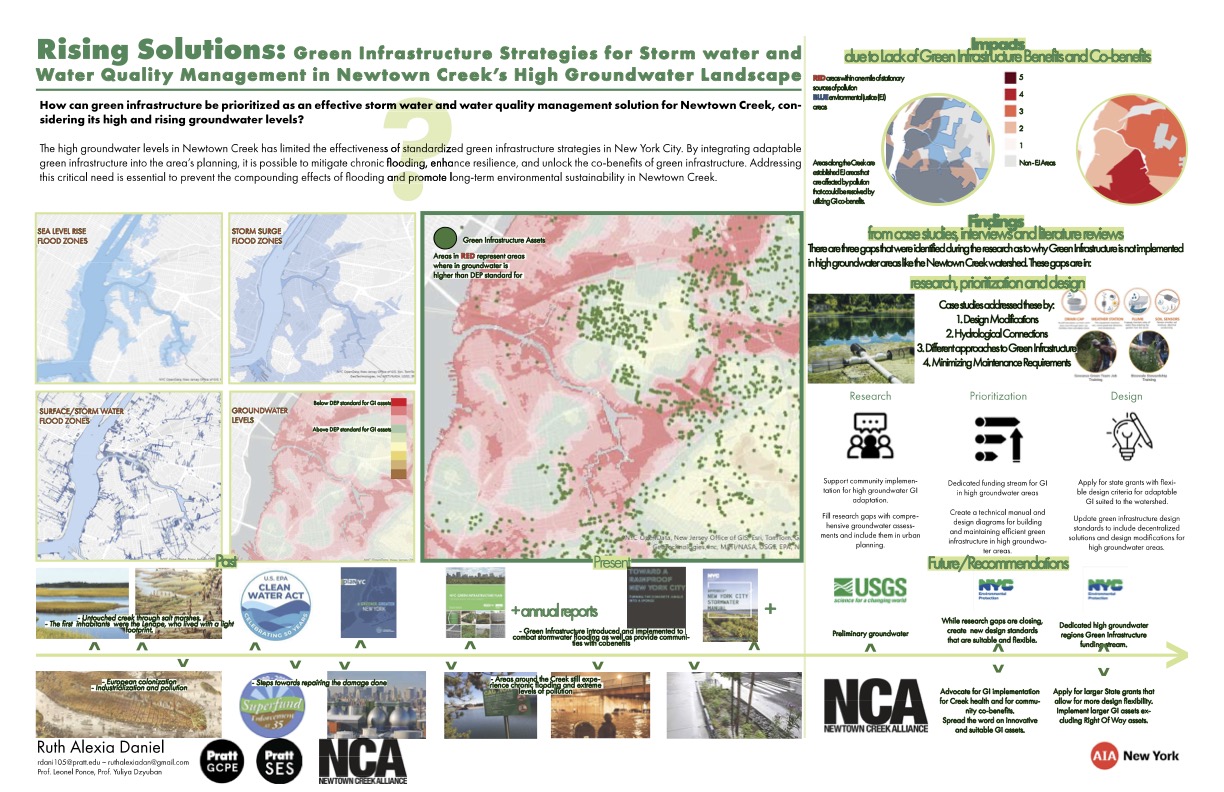
Student: Ruth DanielNewtown Creek is a 3.8-mile tidal waterway that forms the border between Brooklyn and Queens. Once a vital industrial corridor, its shoreline and hydrology were significantly altered to accommodate urban development. Today, the legacy of heavy industrial use, coupled with climate change, leaves the area increasingly vulnerable to flooding.
Surrounding neighborhoods such as Greenpoint, Williamsburg, Long Island City, and Maspeth are facing the growing threat of stormwater and coastal flooding. This is not only due to more frequent extreme rainfall events and rising sea levels but also because of a lesser-known but critical factor: high groundwater levels. As groundwater rises with sea level, it saturates soils, reducing their ability to absorb rainwater and undermining the effectiveness of common green infrastructure techniques like bioswales or rain gardens.
In response, this project, developed for the Newtown Creek Alliance, offers targeted recommendations for green infrastructure solutions specifically suited to areas with high groundwater. Rather than relying on infiltration, which becomes ineffective in saturated conditions, the project highlights alternatives like vegetated retention basins, sealed planting systems, and surface-based storage solutions. These interventions are guided by criteria evaluating environmental impact, cost-effectiveness, ease of implementation, and community co-benefits.
The research draws from both local site conditions and global precedents to understand how other cities have approached similar challenges. Expert interviews provided insights into regulatory, engineering, and ecological perspectives. A central conclusion is clear: green infrastructure can be adapted for high groundwater areas, but citywide planning must begin to explicitly account for this condition to ensure equitable climate resilience.
By prioritizing high groundwater regions like Newtown Creek in planning and funding efforts, New York City has an opportunity to address long-standing environmental burdens while building a more flood-resilient future.
-
July 25, 2025
![Nandini Vavhal - Pratt Institute Design Thesis]() Nandini Vavhal - Pratt Institute Design Thesis
Nandini Vavhal - Pratt Institute Design ThesisSchool: Pratt Institute, School of Architecture
Program: Master of Science in Sustainable Environmental Systems
Project Title: A Path to Recover and Revive: Strengthening Strategies for Disaster Debris Management Following
Coastal Storm Events in New York City
Project Location: New York City
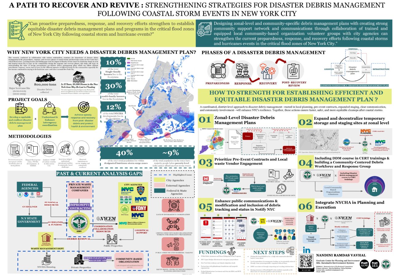
Student: Nandini VavhalAs climate change accelerates the frequency and severity of coastal storms, disaster debris management has become a growing concern in New York City. While attention often focuses on flooding and damaged infrastructure, the massive volume of debris left behind—including construction waste, furniture, electronics, and hazardous materials—can pose a significant threat to public health, disrupt recovery efforts, and exacerbate inequalities in already vulnerable communities.
This capstone project examines how New York City can develop a more resilient and equitable approach to disaster debris management, particularly in flood-prone, underserved neighborhoods such as Red Hook, Coney Island, the Rockaways, and NYCHA public housing developments. These areas are often the hardest hit and face compounded vulnerabilities due to systemic disinvestment and limited access to resources.
In collaboration with the NYC Department of Sanitation (DSNY), the research involved spatial analysis, site visits, stakeholder interviews, and comparative case studies. A review of New York City’s (NYC) response to Hurricane Sandy, alongside Harris County’s approach during Hurricane Harvey, identified critical gaps in NYC’s current system, including inadequate pre-disaster contracting, limited staging sites, poor interagency coordination, and a lack of inclusive communication strategies.
The study recommends the development of Zonal Disaster Debris Management Plans, the expansion and decentralization of storage sites, and the establishment of pre-event contracts with local waste vendors. It also proposes incorporating disaster debris training into NYC’s Community Emergency Response Team (CERT) program and establishing multilingual communication systems tailored to public housing residents.
By embedding community-based organizations and local leadership into planning and response frameworks, New York City can enhance efficiency, prioritize equity, and strengthen community resilience. Note: This project was completed by Nandini Vavhal as part of the Demonstration of Professional Competence (Capstone) course, which culminates the MS Sustainable Environmental Systems curriculum at Pratt Institute, in collaboration with the NYC Department of Sanitation (DSNY) as the client.
-
July 23, 2025
![Breathscape - Junwen Chen Pratt Design Studio Thesis]() Breathscape - Junwen Chen Pratt Design Studio Thesis
Breathscape - Junwen Chen Pratt Design Studio ThesisPratt Institute Design Studio VI Thesis by Junwen Chen
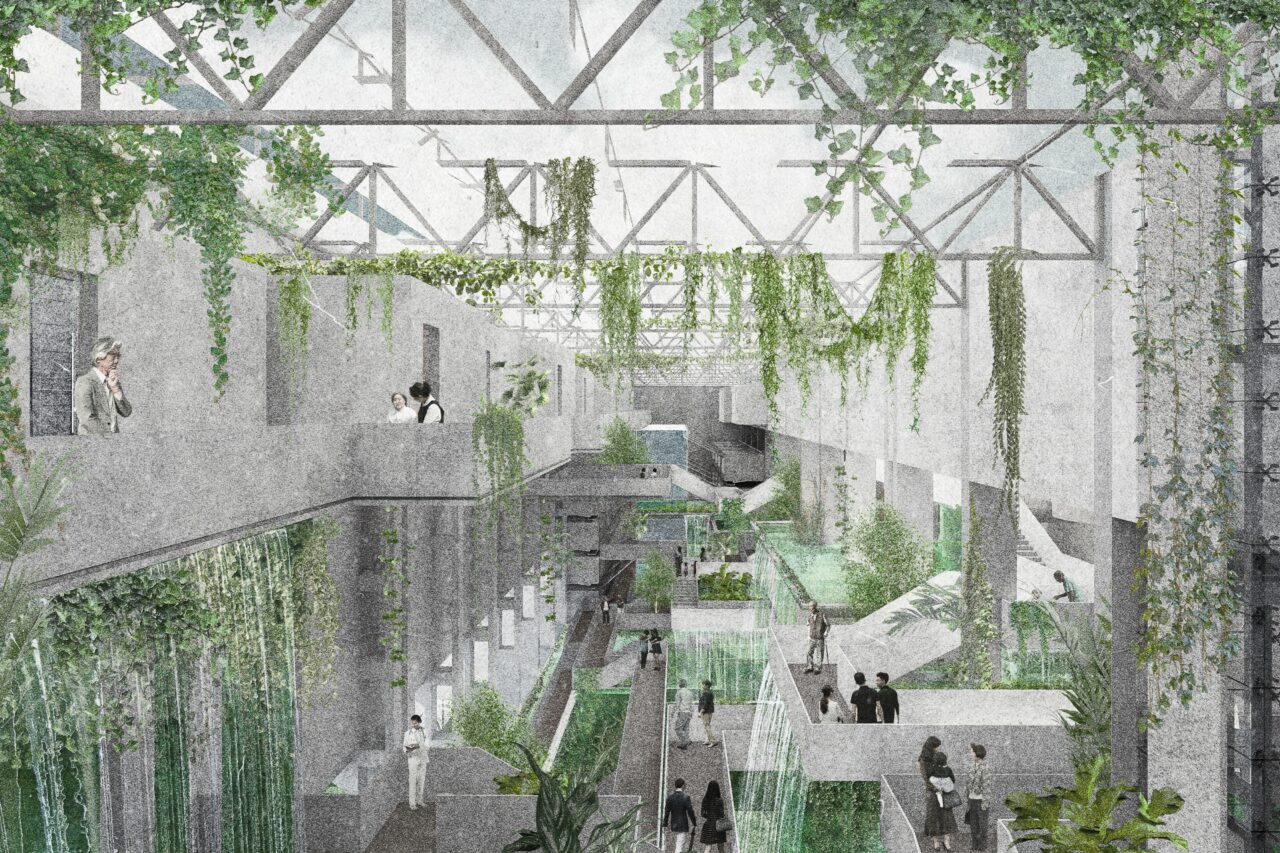
Nanjing, Jiangsu, China – project siteLocated on the slopes of an abandoned steel factory in Nanjing, Breathscape envisions architecture as an active environmental system—one that functions across both interior and regional scales. At its core is a living ecosystem of cascading algae gardens and black soldier fly bioprocessing systems that actively remove CO₂ from the air, capture carbon, purify air, and support human health.
Visitors traverse a sequence of public and private volumes threaded together by terraced algae waterfalls. These flowing systems cleanse incoming polluted air from regional intake vents to interior distribution, while also animating the space with visual movement, shifting light, and reflective surfaces. Once saturated, the algae are harvested and fed to black soldier flies, whose digestive process removes compounds that would weaken concrete and produce carbon-rich plant fibers. These fibers are later mixed into concrete, enabling durable construction and long-term carbon storage.
At the interior scale, the algae systems shape both spatial layout and environmental quality. Pools are integrated into bedrooms, workspaces, quiet and oxygen zones, providing users—especially those with respiratory conditions, mental health concerns, or weakened immune systems—with access to continuously purified air. The immersive environment, enhanced by algae waterfalls, dynamic lighting, and layers of vegetation, redefines healing through both ecological and architectural experience.
By embedding living biological systems into architectural form, Breathscape offers a new model: buildings that go beyond protection and actively contribute to environmental repair and collective health.
-
July 15, 2025
![The Green Stitch NYIT]() The Green Stitch NYIT 4th Year Urban Design Studio
The Green Stitch NYIT 4th Year Urban Design StudioVisiting Professor: Dr Sandra Piesik
Project Title: The Green Stitch
Project Location: Cross Bronx Expressway, Bronx, NY
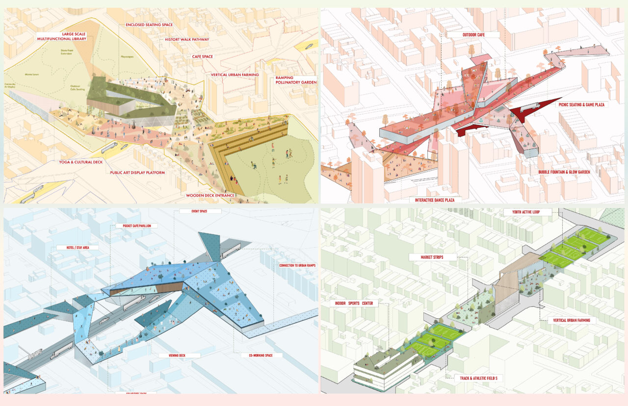
Student Designers: Sivapriya Janakiraman, Yash Oza & Manasi BhiseFor decades, the Cross Bronx Expressway (CBE) has acted less as a piece of infrastructure and more as a scar—dividing neighborhoods, displacing families, and leaving behind fractured green spaces and a deep social disconnect. “The Green Stitch,” a fourth-year urban design proposal from students Sivapriya Janakiraman Yash Oza and Manasi Bhise at the New York Institute of Technology, reimagines the CBE not as a barrier, but as an opportunity for reconnection.
Guided by the studio theme Regenerative Urbanism: One Planet, One Community under Dr. Sandra Piesik, this project aims to transform the expressway into a regenerative landscape—a living infrastructure that heals both ecological and human systems. Inspired by the organizational logic of Physarum polycephalum and the continuous topography of Seattle’s Olympic Sculpture Park, the team developed a sectional strategy that integrates landform, ventilation, water management, and public access into a seamless whole.
The proposal identifies three paradoxes—abundant green fabric without programming, high population density lacking civic infrastructure, and rapid transit systems that ignore local community needs. In response, five programmatic anchors were introduced: a civic spine with libraries and urban farms; cultural zones with dance plazas and cafés; interactive play areas; rest hubs with food vendors and coworking stations; and reprogrammed landscape zones for art and sports.
More than a cap, The Green Stitch is a call to reframe infrastructure as a tool of healing. By listening to community voices and applying regenerative strategies, the project envisions a Bronx where green space isn’t just seen—but lived, shared, and grown into a resilient future.
Committee Meetings
-
Wed, 10/8, 2025, 6:00pm
-
Wed, 11/12, 2025, 6:00pm
-
Wed, 12/10, 2025, 6:00pm
Past Events
-
Mon, 7/7/25, 2:00pm
-
Thu, 5/15/25, 6:00pm
-
Tue, 2/25/25, 5:30pm
-
Thu, 9/26/24, 6:00pm
-
Thu, 7/11/24, 3:45pm



![cocoon[s] location: prototypical dry remote environment](https://www.aiany.org/wp-content/uploads/sites/15/2025/08/Website-Image-1280x720.jpg)
